
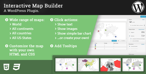

The Interactive Map Builder is a plugin for WordPress and enables you to create interactive maps for your blog. You can configure an extensive set of options to fit the look and feel of your website.
Maps
There are many possible regions to display on a map. For example, you can…
- Create a map of the whole world
- Create a map of any continent .
- Create maps of subcontinents , like Western Europe or North America
- Create maps of any country . There are more than 200 to choose from.
- Create maps of any US-State .
You can find a complete list of all available regions at the end of this page.
Depending on the displayed region on the map, you can set the resolution of the maps borders. The following resolutions are available:
- country borders are available for world, continent and subcontinent maps.
- state and province borders are available for almost all countries, except for some very small countries and islands.
- metro borders are available for the US map and an US-State.
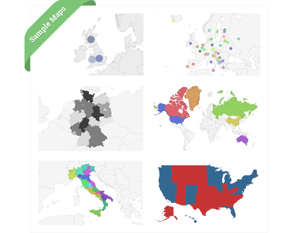
Highlight regions or add markers
There are two different modes available for a map:
- Regions mode can be used to highlight countries, states/provinces and metro-areas.
- Marker mode can be used to mark designated regions using bubbles.
Click Actions
Click Actions allow to add special behaviour to the map when a region or marker is being clicked. The plugin comes with predefined click actions:
- Show Text allows to show additional text for the clicked region or marker below the map.
- Show image opens a lightbox with images.
- Show bars displays a small chart below the map.
- …or create your own click action
Additional interactivity can be added with Tooltips . These become visible when the mouse pointer hits a highlighted region or marker.
The Map Builder
The map builder makes it easy to change the styling of a map.
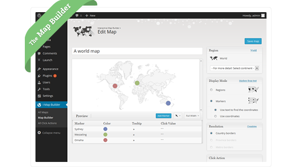
Some of the available customizations are:
- background color of the map,
- height and width,
- border width and color,
- marker size and opacity,
- marker and region colors,
- tooltip styling
All changes become visible right away in a preview. The plugin uses the Google Geo Chart API to render the maps.
Shortcode
Once the map is saved, it can be inserted anywhere in your posts and pages using the shortcode.
Import & Export
Both maps and click actions can be exported and imported. So copying from one blog to another becomes very easy. Most of the examples from this site can be imported with the code below the map. Furthermore, the plugin allows to download an export file of a map to store a backup copy.
HTML5 and SVG
The generated output is cross-browser compatible (with VML for older IE browsers) and also works on mobile platforms like iOS and Android. No plugins are needed.
Responsive
If needed, the maps automatically resize to fit to the available width.
Complete list with all available regions
Table with the possible continents, sub-continents and countries:
Continents (5) |
Sub-Continents (22) |
Countries (236) |
|---|---|---|
| Africa | Northern Africa | Algeria, Egypt, Western Sahara, Libya, Morocco, Sudan, Tunisia |
| Western Africa | Burkina Faso, Benin, Côte d’Ivoire, Cape Verde, Ghana, Gambia, Guinea, Guinea-Bissau, Liberia, Mali, Mauritania, Niger, Nigeria, Saint Helena, Sierra Leone, Senegal, Togo | |
| Middle Africa | Angola, Congo, Central African Republic, Congo, Cameroon, Gabon, Equatorial Guinea, Sao Tome and Principe, Chad | |
| Eastern Africa | Burundi, Djibouti, Eritrea, Ethiopia, Kenya, Comoros, Madagascar, Mauritius, Malawi, Mozambique, Réunion, Rwanda, Seychelles, Somalia, Tanzania, Uganda, Mayotte, Zambia, Zimbabwe | |
| Southern Africa | Botswana, Lesotho, Namibia, Swaziland, South Africa | |
| Europe | Northern Europe | Guernsey, Jersey, Åland, Denmark, Estonia, Finland, Faroe Islands, United Kingdom, Ireland, Isle of Man, Iceland, Lithuania, Latvia, Norway, Sweden, Svalbard and Jan Mayen |
| Western Europe | Austria, Belgium, Switzerland, Germany, France, Liechtenstein, Luxembourg, Monaco, Netherlands | |
| Eastern Europe | Bulgaria, Belarus, Czech Republic, Hungary, Moldova, Poland, Romania, Russia, Slovakia, Ukraine | |
| Southern Europe | Andorra, Albania, Bosnia and Herzegovina, Spain, Gibraltar, Greece, Croatia, Italy, Montenegro, Macedonia, Malta, Serbia, Portugal, Slovenia, San Marino, Holy See (Vatican City State) | |
| Americas | Northern America | Bermuda, Canada, Greenland, Saint Pierre and Miquelon, United States |
| Caribbean | Antigua and Barbuda, Anguilla, Aruba, Barbados, Saint Barthélemy, Bahamas, Cuba, Dominica, Dominican Republic, Grenada, Guadeloupe, Haiti, Jamaica, Saint Kitts and Nevis, Cayman Islands, Saint Lucia, Saint Martin (French part), Martinique, Montserrat, Puerto Rico, Turks and Caicos Islands, Trinidad and Tobago, Saint Vincent and the Grenadines, Virgin Islands (British), Virgin Islands (U.S.) | |
| Central America | Belize, Costa Rica, Guatemala, Honduras, Mexico, Nicaragua, Panama, El Salvador | |
| South America | Argentina, Bolivia, Brazil, Chile, Colombia, Ecuador, Falkland Islands (Malvinas), French Guiana, Guyana, Peru, Paraguay, Suriname, Uruguay, Venezuela | |
| Asia | Central Asia | Turkmenistan, Tajikistan, Kyrgyzstan, Kazakhstan, Uzbekistan |
| Eastern Asia | China, Hong Kong, Japan, North Korea, South Korea, Mongolia, Macao, Taiwan | |
| Southern Asia | Afghanistan, Bangladesh, Bhutan, India, Iran, Sri Lanka, Maldives, Nepal, Pakistan | |
| South-Eastern Asia | Brunei, Indonesia, Cambodia, Laos, Myanmar, Malaysia, Philippines, Singapore, Thailand, Timor-Leste, Vietnam | |
| Western Asia | United Arab Emirates, Armenia, Azerbaijan, Bahrain, Cyprus, Georgia, Israel, Iraq, Jordan, Kuwait, Lebanon, Oman, Palestine, State of, Qatar, Saudi Arabia, Syria, Turkey, Yemen | |
| Oceania | Australia and New Zealand | Australia, Norfolk Island, New Zealand |
| Melanesia | Fiji, New Caledonia, Papua New Guinea, Solomon Islands, Vanuatu | |
| Micronesia | Federated States of Micronesia, Guam, Kiribati, Marshall Islands, Northern Mariana Islands, Nauru, Palau | |
| Polynesia | American Samoa, Cook Islands, Niue, French Polynesia, Pitcairn, Tokelau, Tonga, Tuvalu, Wallis and Futuna, Samoa |
Table with the possible provinces:
Provinces (51) |
|
|---|---|
| United States | Alabama, Alaska, Arizona, Arkansas, California, Colorado, Connecticut, Delaware, Florida, Georgia, Hawaii, Idaho, Illinois, Indiana, Iowa, Kansas, Kentucky, Louisiana, Maine, Maryland, Massachusetts, Michigan, Minnesota, Mississippi, Missouri, Montana, Nebraska, Nevada, New Hampshire, New Jersey, New Mexico, New York, North Carolina, North Dakota, Ohio, Oklahoma, Oregon, Pennsylvania, Rhode Island, South Carolina, South Dakota, Tennessee, Texas, Utah, Vermont, Virginia, Washington, West Virginia, Wisconsin, Wyoming, District of Columbia |
